

Resistivity
Resistivity
Cable
Crossing
Line
Field
Crew
Short explanation of the method
The resistivity of a material describes its "inability" to conduct current. The resistivity of geological materials is largely controlled by the water content of the material, clay mineral and dissolved salts.
Resistivity has many advantages:
-
Resistivity measurements often times paired with refraction seismic as it can provide supporting information about the shape and position of the fracture zones.
-
The method is non-destructive and cheaper to carry out then refraction seismic.
-
The method is able to provide information about sediment (types and thickness) and boundaries in the bedrock
-
2D resistivity measurements works very well for mapping out weakness zone in bedrock under given prerequisites. The method can detect weakness zones, including width and direction and also the depth of it

Electrical resistivity measurements are usually performed by sending current between two electrodes and the potential difference (resistance) is measured simultaneously between two or more other electrodes.
If the distance between the electrodes is known, the "apparent" resistivity of the ground can be calculated (apparent resistivity = a weighting of the resistivity of several geological layers).
By moving the measuring station and varying the distance between electrodes, information about variations in the apparent resistivity of the ground can be obtained towards the depth and in the direction of the profile, a so-called pseudo-section consisting of sometimes several 1000 measuring points. Larger distances between the current electrodes lead to a greater penetration depth.

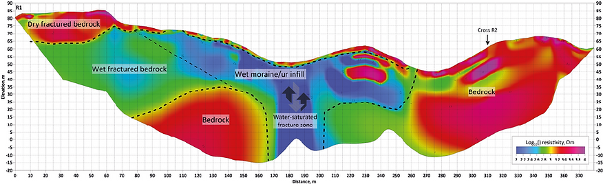
In a subsequent data processing, one or more resistivity models are generated by estimating the "true" resistivities with the aid of tomographic inversion modelling. With knowledge of the electrical properties of different materials (Figure 8), a model can be interpreted in geological terms: identifying different soil layers, rock levels and fracture zones. However, unique identification of the bedrock surfaces is impossible in most cases, but rather identification of zones of various geological origin.
An uncertainty found in the calculated models stems from the fact that there is no unique solution, i.e. one fixed set of measurement data can be explained with several different models. Different geological materials may also have overlapping resistivities. It can be difficult to distinguish a water-saturated clay from a weathered bedrock. Additional uncertainties can come from anthropogenic / urban sources such as electrical installations and wires etc. In addition, both the vertical and lateral resolution decreases with depth.
Electrical methods
Method
Resistance measurement
Equipotential
line
Induced
Polarization
Spontaneous
Potential
Measured Physical Parameter
Voltage drop at applied current. Apparent specific resistance.
The course of an applied voltage field
Time variation of applied voltage
Voltage drop in a natural voltage field
Calculated parameter
Location of boundaries between layers with different conductivity
Location and extent of electrically conductive structures.
Location and extent of formations with electrochemical polarizability.
Location of formations surrounding a natural voltage field
Application
Determination of loose material layers, boundaries between different types of sediments, depth to groundwater. Exploration for ores, petroleum, coal and minerals.
Ore and mineral exploration. Mapping of boundary lines between structures with a difference in electrical properties.
Exploration for ores, minerals and coal. Registration of clay content in sand.
Ore prospecting. Mapping of sedimentary formations, especially in connection with petroleum exploration; groundwater level.
Induced Polarization
Induced polarization (IP) can also carried out along the resistivity measurements. The measurement is done by the same instrument just as resistivity. IP effect is measured as a residual voltage in the ground after a current pulse is sent.
IP measurement can aid the mapping of weakness zone in bedrock with the following information:
-
mineralization of electron-conducting minerals (sulphides, iron oxides or graphite)
-
technical systems that may interfere with the resistivity values
-
possible gangue rocks (syenite, diabase and the like)
-
possible clay in the cracks

